June 6, 2024 -
Routes will remain the same; RIPTA asks for passenger patience as the agency works to build its workforce and reduce missed trips The Rhode Island Public Transit Authority (RIPTA) officially announced today that it will not move forward with previously proposed service reductions, which were scheduled to go into effect on Saturday, June 15, 2024,
August 14, 2025 -
Providence, Rhode Island – The Rhode Island Public Transit Authority (RIPTA) will detour Route 60 (Providence/Newport) and Route 61x (Tiverton/East Bay Park & Ride) to accommodate the closing of the Mount Hope Bridge for repaving. The detour will begin at 7pm on Thursday, August 14 and continue through Sunday, August 17, 2025.
This study is following a prescribed federal process called an “Alternatives Analysis” (AA) as described by the Federal Transit Administration, which includes consideration a wide range of public transportation or multimodal alternatives to address transportation problems within a corridor or subarea. The outcome of the AA will:
Recommend the best routes and types of transit (both bus rapid transit (BRT) and light rail transit (LRT) are under consideration)
Suggest bus stop and station locations
The AA will also develop a service plan and an order-of-magnitude cost estimate for building and operating the high-capacity transit service.
The AA will also develop a service plan and an order-of-magnitude cost estimate for building and operating the high-capacity transit service.
What modes and alignments will be analyzed in the Metro Connector study? +
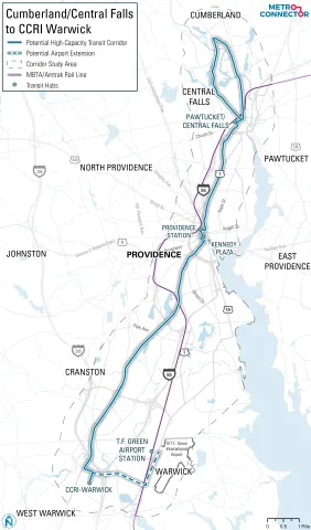
The Metro Connector study area includes the communities of Cumberland, Central Falls, Pawtucket, Providence, Cranston, and Warwick. There are two corridors being considered as part of this effort: the first travels from Cumberland to the Community College Rhode Island (CCRI) via downtown Providence, and the second travels from Providence to TF Green International Airport. The study is exploring the costs and benefits of both Light Rail Transit (LRT) and Bus Rapid Transit (BRT).
What is the expected outcome of the Metro Connector study? +
The outcome of this study will result in a recommended alignment (or alignments) for high-capacity transit, a recommended mode, and general stop or station locations. The effort will also prepare order-of-magnitude capital and operating costs and anticipated benefits.
What is the Metro Connector study area? +
The Study area extends from Cumberland at the north to Warwick at the south and includes portions of Central Falls, Pawtucket, Providence, and Cranston.
What is high-capacity transit? +
High-Capacity Transit, or Rapid Transit, is a form of public transportation that includes features that significantly improve the speed, frequency, and quality of service. It includes enhanced features such as stations, dedicated running ways and/or transit signal priority, high-capacity vehicles, and more.
Why build high-capacity transit? +
High-capacity transit improves local and regional mobility. The study was recommended in RI’s 2020 statewide Transit Master Plan, Transit Forward RI 2040. This plan examined transit demand throughout the state and identified the transit lines in this study as a priority because they have the highest ridership demand in Rhode Island, comparable to transit lines in much larger cities around the US.
What is the schedule for the Metro Connector Study and when will the locally preferred alternative (LPA) be decided? +
The study began is Spring 2024 and will have multiple points for public input throughout. The study is expected to conclude by mid-2026. Once this study is completed, the project would be ready to request from the Federal Transit Administration entry into the Project Development process, which would include preliminary and final design, utility and right-of-way coordination, and environmental clearance.
Who will approve the Locally Preferred Alternative (LPA)? +
The Locally Preferred Alternative would be approved by a vote of the RIPTA Board of Directors at the conclusion of the Study. RIPTA will seek an indication of support of the Locally Preferred Alternative from the municipalities along the corridor and will forward the LPA to the Rhode Island Division of Statewide Planning for inclusion in the Transportation Improvement Plan (TIP).
How is the Metro Connector Study funded? +
This study is being led by the Rhode Island Public Transit Authority (RIPTA) through a variety of funding sources, the largest of which was received from the United States Department of Transportation’s (USDOT’s) Rebuilding American Infrastructure with Sustainability and Equity (RAISE) grant program. The study is also using FTA 5307 formula funds made available through the Bipartisan Infrastructure Investment and Jobs Act (IIJA), and from the Rhode Island Unified Planning Work Program (UPWP).
How can I be involved in the process? +
Community input will be collected throughout the Metro Connector study through both in-person and online events. Please sign up here to be added to our email list. You may also contact RIPTA’s Project Manager Zachary Agush at MetroConnector@ripta.com.
The Metro Connector Study has identified six project goals. These goals were informed by feedback from members of the community and stakeholder agencies, and through a review of the specific goals articulated in Transit Forward RI, Moving Forward RI (the State’s Long Range Transportation Plan), the RI Act on Climate, and various State and local policies relating to transportation, public health and community development.
Regional rapid transit connecting the communities of Cumberland, Central Falls, Pawtucket, Providence, Cranston and Warwick is aimed at improving mobility for people living, working, and visiting these areas, and enhancing access to regional destinations including employment centers, educational campuses, healthcare facilities, social services, the airport, and commercial centers. This would be done by reducing transit travel times and increasing the frequency, reliability, and convenience of transit.
The six project goals are as follows:
Grow Transit Ridership: Connect areas that have high demand for transit by providing fast, frequent, and reliable service that is competitive with driving.
Enhance Connectivity: Improve multi-modal connections between regional transportation centers and support Complete Streets that provide safe pedestrian and bicycle access.
Focus on Equity: Provide rapid transit where and when transit-critical populations are traveling, that allows these residents to stay in their neighborhoods.
Support Sustainable Growth: Support smart and compact transit-oriented development (TOD) in designated growth districts and frequent transit corridors. Reduce greenhouse gas emissions by encouraging mode-shift to transit, walking, and biking.
Support our Economy/Provide New Opportunities: Improve access to regional employment, workforce education, medical and social services, shopping, and other activities to create new opportunities for regional residents.
Focus on Practical and Implementable Solutions: Achieve local consensus on an option that balances costs and benefits, aligns with local goals, and can be reasonably implemented.
The Metro Connector study will explore options for light-rail and bus rapid transit to connect the communities of Cumberland, Central Falls, Pawtucket, Providence, Cranston, and Warwick. The study aims to:
Recommend the best routes and types of transit
Suggest station locations
Estimate the costs of building and operating the system
Identify the expected benefits of the project
The purpose of the study is to consider options for providing fast, frequent, and reliable transit that connects regional activity centers, residential neighborhoods, business districts, and major transportation hubs across metropolitan Providence. It also seeks to support other State goals related to climate, sustainable housing growth, and economic development in an equitable manner.
The study was recommended in RI’s 2020 statewide Transit Master Plan, Transit Forward RI 2040 and began in Spring 2024. This plan examined transit demand throughout the state and identified the transit lines in this study as a priority because they have the highest ridership demand in the Rhode Island, comparable to transit lines in much larger cities around the US.
The Metro Connector project provides many opportunities for community members to become involved, through participating in public meetings to be held at key moments in the project, through public surveys administered through this project website, and at pop-up events that will be held throughout the project. Please sign up here to be added to our mailing list to learn more about upcoming meetings and ways to engage with the project team.
When Is The Study Happening?
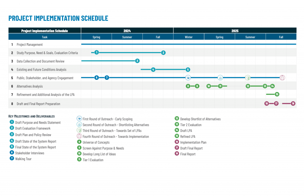
The Metro Connector study began in Spring 2024 and is expected to continue through mid-2026. This detailed timeline shows when the technical work will occur and how technical efforts feed into community engagement milestones. Each circled number in the timeline corresponds to a deliverable for the project, color coded into four colors.
For more information, please contact RIPTA’s Project Manager Zachary Agush at MetroConnector@ripta.com
RIPTA Routes 3, 4, 51, 54, 58, and 72 operate along the corridor. Routes 1 and 92 also serve some DTC stops.
Why don’t more RIPTA routes travel along the DTC corridor? +
We believe a 5-minute frequency is appropriate to meet passenger demand in the downtown DTC corridor. Some routes (i.e. RIPTA Routes 1 and 92) serve certain DTC stops, but not the entire corridor. Additional routes could travel via the corridor in the future.
Where are dedicated bus lanes located? +
Dedicated bus lanes are located: along Eddy Street (north of RI Hospital) and near South Street Landing; on Dyer Street (in the southbound direction near the new Wexford development); and along Exchange Street (between Kennedy Plaza and Providence Station). Bus lanes are also located at all DTC stop locations, including the full northbound block of Dorrance Street between Friendship and Pine and the southbound block between Weybosset and Pine.
What types of vehicles are used? +
RIPTA is using buses from our regular bus fleet. However, as we continue to transition to electric buses it is likely that some of these buses will operate along the DTC.
Can other vehicles use the bus lanes? +
Emergency vehicles are able to use DTC bus lanes, as well as any vehicle making the next available right-turn.
How are “no parking” and “no driving” rules in the bus lanes enforced? +
RIPTA and the City of Providence are working together to establish rules for the bus lanes. New legislation or ordinances may be required. We also believe it will be important to conduct a campaign to educate downtown drivers about any restrictions.
Will any dedicated bicycle lanes be added? +
Bicycle lanes were installed on Exchange St. leading to Providence Station, and possibly on certain segments in the Jewelry District. For safety reasons, bicycles are not allowed in the dedicated bus lanes.
What is Transit Signal Priority (TSP) and how does it work along the DTC? +
Transit Signal Priority (TSP) adjusts the timing of a traffic signal’s red and green cycles to reduce the amount of time a transit vehicle spends waiting at a red light. Extending green lights for buses along the R-Line reduced the overall travel time by 10%. We believe it will reduce future bus travel times along the shorter DTC corridor between RI Hospital and Providence Station by about 20%. TSP will also make travel times along the DTC more reliable, which will help create a service more people can depend on.
What type of information is displayed at DTC stops? +
Real-time information displays show bus schedules as well as changes and disruptions to service. These smart displays also offer additional information about area attractions and events. If you have any suggestions for information you would like to see or that will make your trip easier, please let us know.
How was the DTC project funded? +
There was $17 million available to design and construct the project, including a $13 million federal grant for the project and $4 million from RIPTA and the State of Rhode Island.
How are stops and shelters along the route maintained? +
RIPTA cleans and maintains bus shelters using in-house maintenance staff or private contractors. Unfortunately, with about 3,500 bus stops in our statewide system, we are not able to remove snow at all locations. However, we may try to find local partners to adopt DTC stops for light cleaning and snow removal.
We carefully considered maintenance needs as part of our design process and have constructed shelters and other amenities to be as resistant as possible to damage and vandalism. Instead of glass panels, we used a polycarbonate material and RIPTA has an inventory of replacement panels on hand in case of damage.